
‘Alien-like’ Tropical Storm Earl forms east of the Caribbean, Danielle weakens

Gavin Riley / Our Today
administrator
Interests in the Eastern Caribbean, especially the US Virgin Islands and Puerto Rico, have been alerted for Tropical Storm Earl, which creeps ever so closely to the Leeward Islands today (September 3), hours after strengthening from a tropical depression late Friday night.
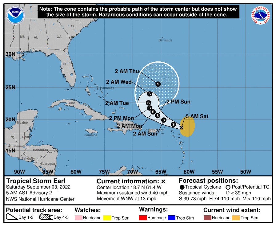
The US-based National Hurricane Center (NHC), in its 5:00 am Eastern Standard Time (EST) bulletin tracking the fifth named storm of the 2022 season, located the centre of Tropical Storm Earl near latitude 18.7 North and longitude 61.4 West.
While there are currently no tropical storm watches or warnings activated, Earl, roughly 190 kilometres east-northeast of the northern Leeward Islands, is moving west-northwest briskly at 20 kilometres/hour. Tropical Storm Earl is also packing maximum sustained winds at 65 kilometres/hour, with higher gusts.
On the forecast track, NHC meteorologists indicated that the centre of Tropical Storm Earl could pass just north of the northernmost “Leeward Islands today, and north of the Virgin Islands and Puerto Rico tonight and Sunday”.
The NHC also indicated that further development is possible over the next few days as tropical-storm-force winds extend outward up to 280 kilometres mainly to the north and east of Earl’s centre.
For its part, the Antigua and Barbuda Meteorological Services advised that its tropical cyclone alert remains in effect for the northern Leeward Islands, with threat levels being particularly elevated for Anguilla.
“Earl is expected to produce total rainfall amounts of one-to-four inches, with isolated totals of six inches, across parts of the Leeward and British Virgin Islands through this weekend. Minor flash flooding is expected. Strong gusty winds, especially in squalls, are also possible across portions of the Leeward Islands and the Virgin Islands,” the agency noted.
“Additionally, swells from this system could produce hazardous marine conditions for beach-goers during the weekend. Residents are urged to monitor Tropical Storm Earl closely and be prepared to take quick action to implement their hurricane plans if called upon to do so. The threat is minor, at this time, but it could increase,” Antigua’s met service added.
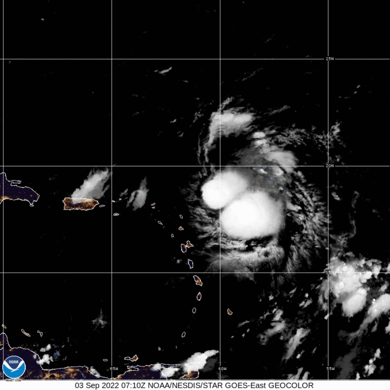
Computer-generated projections of the path of Tropical Storm Earl see the ‘alien-looking’, twin-centre system skirting just past the fringes of the Leeward Islands out into the open ocean by late Sunday.
In the meantime, NHC sleuths have downgraded Danielle to a tropical storm, as the disturbance remains “nearly stationary” some 1,450 kilometres west of The Azores.
As at 9:00 Greenwich Meridian Time (GMT), the centre of Tropical Storm Danielle was located near latitude 38.0 North and longitude 43.8 West. ‘Moving’ west at two kilometres/hour, the system’s maximum sustained winds have decreased to near 110 kilometres/hour, with higher gusts.

While little change in strength is expected for today, some slight strengthening is expected tonight through Monday, with the NHC anticipating Danielle to regain hurricane strength on Sunday.
Tropical Storm Danielle remains no direct threat to land at this time.


Comments