Caribbean on alert as Erin set to strengthen into hurricane

/ Our Today
administrator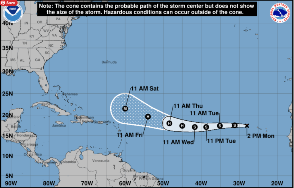
Durrant Pate/Contributor
Tropical Storm Erin is forecast to rapidly strengthen into a hurricane this weekend, as it nears the northeastern Caribbean and Bahamas, raising concerns for strong winds, heavy rain and dangerous surf along the islands.
However, it could still be a couple of days before it reaches hurricane status, AccuWeather meteorologists caution. Erin has already proven its potential by producing deadly flash flooding in the Cabo Verde Islands this past weekend, around the time it developed.
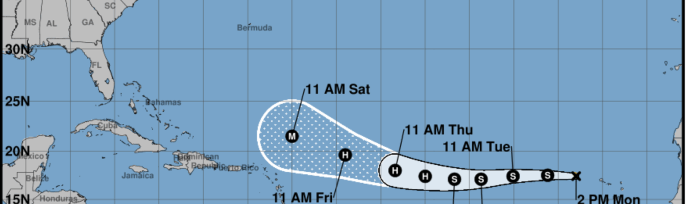
AccuWeather meteorologists expect Erin to become the season’s first Atlantic hurricane and reach the intensity of a Category 3 or stronger (111 mph or greater) on the Saffir-Simpson Hurricane Wind Scale. As winds increase, waves will propagate outward from the centre. Over the deep sea, these will be large swells.
Swelling near the northern coasts of the Leeward Islands
As the swells near the northern coasts of the Leeward Islands, British and U.S. Virgin Islands, Puerto Rico, Hispaniola and the northeast-facing shores of the Bahamas, dangerous surf and strong rip currents will result. An increasing northwestward drift, then a northward turn, is anticipated as Erin gains some strength.
How quickly that begins, along with the overall strength of Erin, will determine the amount of wind, downpours and thunderstorms that occur in the northeastern islands of the Caribbean. Interestingly, Bermuda is in the path of Tropical Storm Erin.
AccuWeather Chief On-Air Meteorologist Bernie Rayno reports, “Our team of meteorologists at AccuWeather, led by Hurricane expert Alex DaSilva, remains highly concerned for a period of rapid strengthening from late this week to early next week.”
The amount of wind and rain that occurs over the northeastern Caribbean islands and the Bahamas will depend on Erin’s size, intensity and its ability to pull moisture northward from the Caribbean.
Track and strength of Erin
A smaller centre may correspond to little or no rainfall. A more sprawling centre with a plume of tropical moisture could lead to torrential downpours with dangerous flash flooding and mudslides in some areas.
The forecast rainfall, wind intensity and overall impact in the Leeward Islands and Puerto Rico could change depending on the track and strength of Erin. Beyond the Caribbean, impacts on Bermuda, the U.S. and Atlantic Canada will depend on when Erin turns to the north and the forecast hurricane’s intensity.
At the very least, building seas will pose threats for small craft and larger ocean-going vessels over the western Atlantic. Experts say increasing surf and rip currents will pose dangers for swimmers over much of the U.S. Atlantic coast and Bermuda.


Comments