Heavy rains from Eta trigger flash flood warnings in Jamaica, Cayman Islands

Gavin Riley / Our Today
administrator
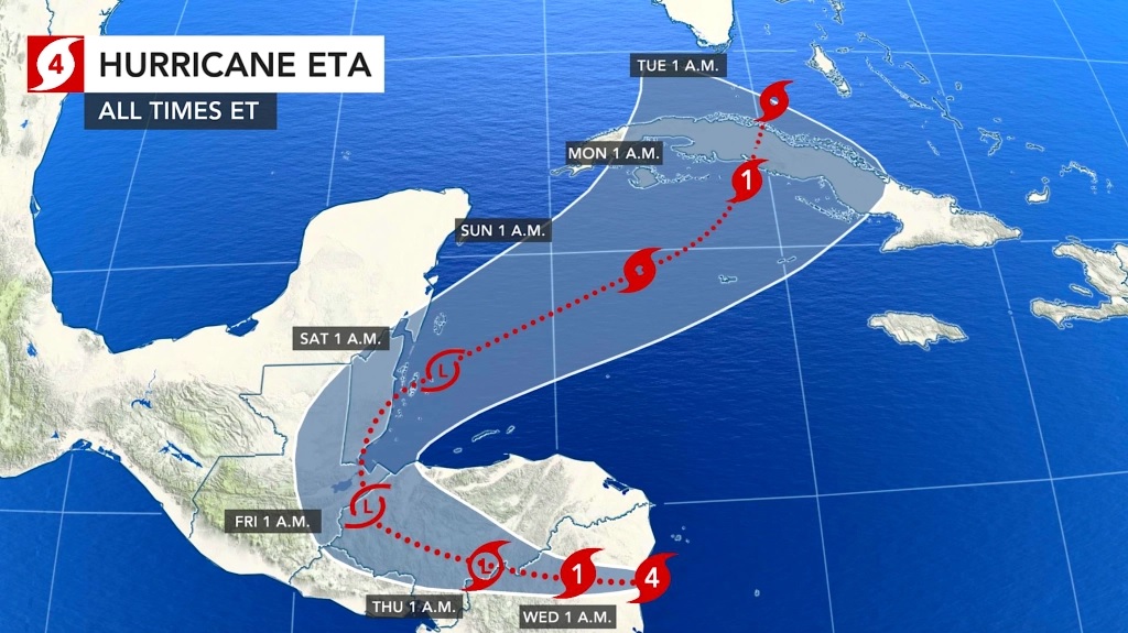
As the outer bands of Hurricane Eta blanket much of the western Caribbean, the Cayman Islands and Jamaica have activated a flash flood warning for much of their jurisdictions on Tuesday (November 3).
The flash flood warning for low-lying and flood-prone areas is now in effect for the parishes of Westmoreland, St Elizabeth, Manchester, Clarendon, St Catherine, Kingston, St Andrew, St Thomas, Portland and St Mary.
In its late-afternoon outlook, the Jamaica Met Service further indicated that an induced trough associated with Hurricane Eta will continue to produce widespread rainfall and occasional thunderstorms.
Inclement weather is expected to persist across the island well into the weekend.
Meanwhile, the met office noted that a small craft warning remains in effect for inshore and offshore areas of Jamaica’s north and south coasts due to strong winds and rough seas, especially in the vicinity of thundershowers.
According to the US-based National Hurricane Center (NHC), Jamaica, southern Haiti and the Cayman Islands could experience up to 15 inches (380 mm) of rain in isolated showers over the next 48 hours.
In the Jamaica Met Office’s three-day forecast, it expects conditions to be overcast through to Saturday—with widespread showers and isolated thunderstorms across the island.
Jamaicans have also been urged to brace for gusty, windy conditions across most parishes, particularly along the south and northeast sections of the country.
Similar small craft and flash flood warnings have been activated in the Cayman Islands, with the territory’s six districts on high alert.
“Intermittent showers along with fresh to strong easterly winds and rough seas are expected across the Cayman area over the next few days as Hurricane Eta moves across Nicaragua and Honduras. Radar images show scattered showers in and around the Cayman area which are moving towards the west to southwest,” the National Weather Service advised in an afternoon bulletin.
The five-day forecast for the Cayman Islands is equally bleak: grey skies, cold and wet conditions through to Sunday.
As at 10:00 pm Eastern Standard Time (EST), Hurricane Eta was located at latitude 13.8 North and longitude 84.0 West—or roughly 70 kilometres west-southwest of Puerto Cabezas, Nicaragua.

The system has already weakened since slamming into Central America, now packing maximum sustained winds of 165 kilometres/hour, with higher gusts.
The category two hurricane continues on its westerly trajectory at nine kilometres/hour.
Hurricane-force winds continue to extend outward up to 35 kilometres from Eta’s centre, while tropical-storm-force winds extend up to 185 kilometres.
The latest minimum central pressure reported by National Oceanic and Atmospheric Administration (NOAA) reconnaissance aircraft is 970 millibars (28.65 inches).


Comments