
No deaths recorded as eyewall of damaging Hurricane Beryl brushes Jamaica’s south coast

Gavin Riley / Our Today
administrator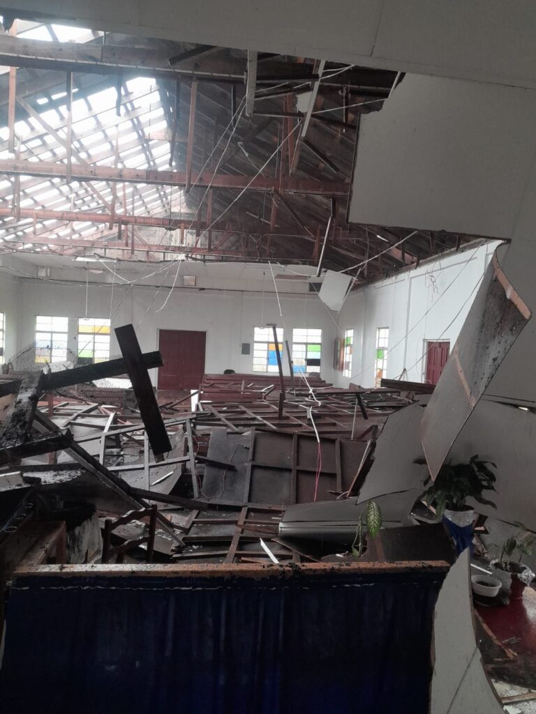
Hurricane Beryl continues to pummel Jamaica with damaging winds, torrential rain and high storm surge on a path of destruction through the northwestern Caribbean this afternoon (July 3).
The system, which was initially forecast to weaken while clearing the island’s territorial waters by 6:00 pm local time, has its forward speed slightly slowed around midday but remains a dangerous hurricane.
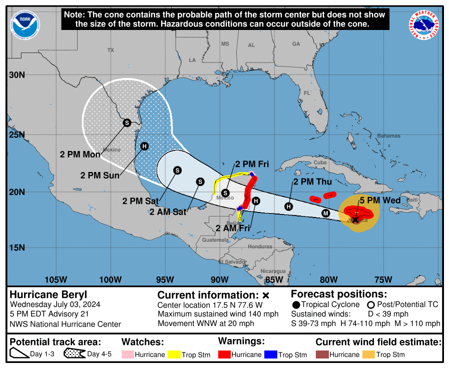
As at 5:00 pm Eastern Daylight Time (EDT), the centre of Hurricane Beryl was located near latitude 17.5 North, longitude 77.6 West—or roughly 100 kilometres west-southwest of the capital Kingston.
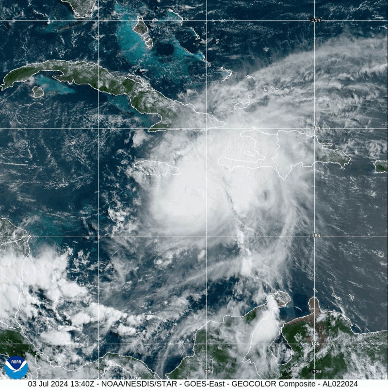
Maintaining its Category 4 intensity, Beryl is barrelling west-northwest at 31 kilometres/hour and currently packs maximum sustained winds near 220 kilometres/hour, with higher gusts.
Hurricane-force winds extend outward up to 75 kilometres from the centre and tropical storm-force winds extend outward up to 295 kilometres.
In its 5:00 pm bulletin, the Meteorological Service of Jamaica advised that the hurricane warning issued for the island is still active as Beryl churns generally westward.
“Hurricane Beryl continues to move along the southern coastline of Jamaica…with dangerously high water, exceptionally high waves and average winds of at least 119 kilometres/hour,” the agency noted.
“The centre of Hurricane Beryl is expected to continue moving adjacent to the southern coastline of Jamaica this afternoon before moving away from the island during the evening,” the Met Service added.
Extensive infrastructural damage has been reported island-wide, particularly in Montego Bay, where a bridge collapsed after residents lit a fire to get rid of accumulating debris and the Norman Manley International Airport, which suffered sections of torn-off roofing. The parishes of St Thomas, Portland and Clarendon have been among the areas hardest hit by Hurricane Beryl.
Norman Manley Airport pic.twitter.com/fccIk4uQ9j
— RoostersWorldja (@RoostersWorldja) July 3, 2024
The Office of Disaster Preparedness and Emergency Management (ODPEM), during a press briefing this afternoon, disclosed that some 488 Jamaicans are being housed in State-run shelters island-wide.
ODPEM, in updates throughout the day, noted that several sections of the country remain blocked or impassable at this time.
| Parish | Areas blocked/impassable |
| St Elizabeth | Holland Bamboo Gutters to Tombstone Goshen main road |
| Westmoreland | Barracks Road, Savanna-la-Mar |
| Hanover | Riley to Glasgow main road, Kingsvale Riley to Bushmouth |
| St Ann | Alexandria to Grenock Bridge |
| St Mary | Robins Bay Bellfield Road Junction |
| St Catherine | Bog Walk Gorge Ewarton main road Linstead main road Vanity Fair bridge, Linstead Above Rock and Bog Walk in the vicinity of Edwards Piece |
| Kingston & St Andrew | Lyndhurst Road Gordon Town main road Crescent and St Joseph roads, leading to Spanish Town Road Port Royal main road Temple Hall main road Longwall Road, Stony Hill |
| St Thomas | Roselle main road |
| Portland | Port Antonio to Nonsuch Fair Prospect to Folly |
At today’s press briefing, Prime Minister Andrew Holness said he was advised that ODPEM has adequate supplies and provisions to ensure that the needs of persons in shelters are addressed.

There have been no reports of deaths associated with Hurricane Beryl’s passage at this time.
Meanwhile, Holness also informed that there have been reports of storm surge affecting parts of the country, including St Thomas, adding that he expects to hear some reports coming out of the southwestern end of the island, such as Portland Cottage in Clarendon.
“That means that the Government will have to mobilise persons very quickly to ensure that the coastal infrastructure, which is critical to the road network, can be cleared very quickly,” he said.


Comments