
LIVE: Outer bands of Hurricane Ian lash sections of Jamaica, flash flooding alerts still in effect

Gavin Riley / Our Today
administrator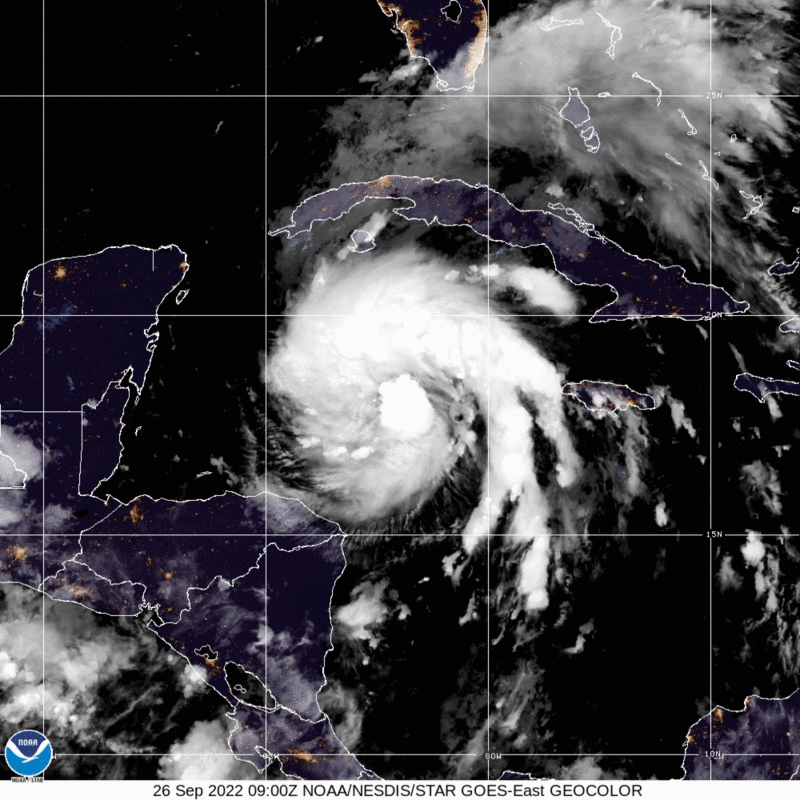
As the outer bands of a massive Hurricane Ian continue to impact the entire island, several major roads have been deemed impassable due to high volumes of floodwaters or structural damage.
The Jamaica Constabulary Force (JCF) and the National Works Agency (NWA) both advised that the heavily commuted Bog Walk Gorge in St Catherine has been ordered closed. Motorists are being urged to seek alternate routes at Barry and Sligoville where feasible.
Also affected are Manchester Road in May Pen, Clarendon, which is now impassable. Motorists should exercise extreme caution at the Thatch Water Bridge in Aenon Town, Clarendon, as rising water levels threaten to inundate the roadway, according to the NWA.


A landslide has severely impacted the Kupuis to Colonel’s Ridge main road in Clarendon.
Structural breakaway of the lower Chapleton to Rock River Road, also in Clarendon, has rendered the thoroughfare impassable.
Robert Nesta Morgan, Member of Parliament for North Central Clarendon, indicated that roadways in the community of Bucknor and Woods are also flooded. Bucknor and Woods, according to the MP, are main entry routes in North Central Clarendon.
Main entry route into my constituency.
— Robert Nesta Morgan (@NestaJA) September 26, 2022
Advising persons to not seek to enter Woods. pic.twitter.com/YQ5Us7DnlT
More details (with periodic updates) below:
| Parish | Location | Status |
| Clarendon | Denbigh-Manchester Avenue main road and adjoining roads | Impassable |
| St Catherine | Big Pond and main road (north of Old Harbour) | Flooded |
| St Andrew | Marcus Garvey Drive | Flooded in sections/impassable |
| Kingston | Church Street-Harbour Street | Flooded |
| Portland | North Coast Highway (in vicinity of Hope Bay and St Margaret’s Bay) | Silt washdown impact |
| Clarendon | Trout Hall Main Road | Impassable |
| Clarendon | Pennants Main Road | Blocked by fallen trees |
| St Catherine | Spanish Town-Port Henderson Road (aka Bernard Lodge road) | Impassable to small vehicles |
| Westmoreland | Hopeton-Auchindown main road Torrington-Pennycooke main road Ferris-Mackfield main road | Impacted by landslides |
| Clarendon | Freetown-Four Paths main road | Flooding |
| St Catherine | St John’s Road | Impassable due to flooding |
| Clarendon | St John’s-Pleasure River road | Impacted by fallen utility pole |
| Trelawny | Wire Fence-Warsop main road | Impacted by landslide; reduced to single-land traffic |
Earlier today, the Jamaica Meteorological Service noted that its flash flood warning was extended to 5:00 am on Tuesday and covers low-lying and flood-prone areas in the parishes of St Mary, Portland, St Thomas, Kingston and St Andrew, St Catherine and Clarendon.
The entity also upgraded a flash flood watch to a warning for Manchester, St Elizabeth and Westmoreland.
Ian, which has battered Jamaica with heavy rains and gusty winds since forming into a tropical storm on Saturday, is expected to dump an additional, isolated maximum of five inches of showers on the southern coast, according to the US-based National Hurricane Center (NHC).

As at 11:00 am Eastern Daylight Time (EDT), the centre of Hurricane Ian was located near latitude 19.1 North and longitude 82.7 West—or roughly 160 kilometres west of Grand Cayman.
The rapidly intensifying system is moving northwest at 20 kilometres/hour, packing maximum sustained winds near 130 kilometres/hour, with higher gusts.


Comments