
Saharan dust plume creeps closer to Jamaica; more of the Caribbean under its influence

Gavin Riley / Our Today
administrator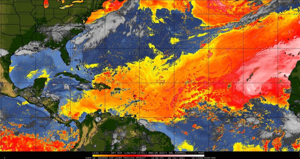
Jamaicans should brace themselves for gradually hazy conditions tomorrow as the latest plume of Saharan dust tracks just east of the island on Tuesday (July 20).
Satellite imagery tracking the Saharan Air Layer (SAL), shows the dust cloud has covered a much wider area of the Caribbean basin over the last 24 hours; from the archipelago’s eastern fringes to Hispaniola and the Turks and Caicos Islands in the west.
Similarly to yesterday, the haze advisories issued by the Trinidad and Tobago and St Lucia meteorological services remain intact, with agencies in Haiti and Barbados releasing modified bulletins.
In its alert, the HydroMeteorological Unit of Haiti (UHM) warned of “dry, less humid weather” associated with the intrusion of Saharan dust, adding that daytime temperatures could soar to 37 degrees Celcius in some sections of the country.
“A few showers and thunderstorms isolated at the mercy of local effects and the diurnal cycle are, however, possible in some of our departments in the afternoon and evening today,” the UHM explained.
For its part, the Jamaica Meteorological Service said mixed conditions would greet citizens today as a high-pressure ridge and low-level jet stream continue to dominate local skies.
In its 5:00 am forceast, the Met Service indicated that isolated morning showers are likely across eastern parishes, with windy conditions persisting along Jamaica’s southern coast.
Later today, isolated afternoon showers and thunderstorms could be in store for hilly areas and western parishes, while it should be partly cloudy elsewhere. Southern parishes will still have to contend with gusty winds.
The maximum temperature expected for cities Kingston and Montego Bay today is 33 degrees Celcius.
Breakdown of towns and cities forecast:
| Towns and Cities | Forecast |
| Morant Bay | Morning showers/Partly cloudy afternoon |
| Kingston | Partly cloudy afternoon |
| Half-Way-Tree | Partly cloudy afternoon |
| Portmore | Partly cloudy afternoon |
| Spanish Town | Afternoon thunderstorms |
| May Pen | Partly cloudy afternoon |
| Mandeville | Partly cloudy afternoon |
| Santa Cruz | Afternoon thunderstorms |
| Black River | Afternoon showers |
| Savanna-La-Mar | Afternoon thunderstorms |
| Negril | Afternoon thunderstorms |
| Port Antonio | Morning showers/Partly cloudy afternoon |
| Port Maria | Partly cloudy afternoon |
| Ocho Rios | Partly cloudy afternoon |
| St Ann’s Bay | Partly cloudy afternoon |
| Browns Town | Partly cloudy afternoon |
| Falmouth | Partly cloudy afternoon |
| Montego Bay | Partly cloudy afternoon |
| Lucea | Afternoon thunderstorms |
The Jamaica Met Service is reminding fisherfolk and marine interests that a small craft warning remains in effect for inshore and offshore areas of the north and south coasts due to strong winds and rough seas.
For more, see the Met Service’s three-day outlook:
Wednesday: Mainly sunny and windy.
Thursday: Partly cloudy morning for eastern parishes. Isolated afternoon showers and thunderstorms for southwestern parishes. Windy.
Friday: Fair to partly cloudy and windy.


Comments