Tropical Storm Bill forms in the Atlantic, NHC expects system to grow then fizzle

Gavin Riley / Our Today
administrator
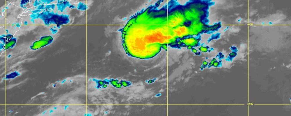
Becoming the second named system of the 2021 hurricane season, Tropical Storm Bill is expected to further strengthen in the Atlantic Ocean on Tuesday (June 15), before fizzling out.
According to meteorologists at the US-based National Hurricane Center (NHC), Tropical Storm Bill, which formed around midnight, was located at latitude 38.5 North and longitude 67.2 West—or roughly 385 kilometres southeast of Nantucket, Massachusetts.
The storm, posing no direct threat to land, is moving northeast at 50 kilometres/hour and packs maximum sustained winds of 85 kilometres/hour.

“Little change in strength is expected today, followed by gradual weakening tonight and Wednesday morning when TS Bill will be moving over colder water. The system is forecast to become a post-tropical low by tonight and dissipate on Wednesday,” the NHC advised.
Weather sleuths at the Florida-headquartered NHC continue to track two other systems off the West African coast and in the Gulf of Mexico.
In its forecast, the NHC said that disorganised showers and thunderstorms persist over the Bay of Campeche and southern Mexico in association with a broad low-pressure area.
“This system is expected to move little during the next day or two, and any development should be slow to occur during that time period,” the morning bulletin indicated.
“However, the disturbance should begin to move northward by Thursday, and a tropical depression is likely to form late in the week when the [system] moves across the central or northwestern Gulf of Mexico,” the hurricane watchdog added.

Its chances for development have increased over the last 24 hours, up to a ‘high’, 70 per cent likelihood.
Regardless of development, heavy rainfall will continue over portions of Central America and southern Mexico during the next several days. Heavy rains could also begin to impact portions of the northern Gulf Coast on Friday.
The second system, a tropical wave hundreds of miles south of the Cabo Verde Islands, has become less organised over the past several hours, the NHC observed.
“Development, if any, should be slow to occur during the next couple of days while the wave moves westward. Thereafter, a combination of dry air aloft and strong upper-level winds should limit the chances of formation when the wave reaches the central tropical Atlantic,” the NHC advised, adding that showers and thunderstorms associated with the tropical wave have decreased.


Comments