TS Iota is here: A reeling Central America braces for more trouble

Gavin Riley / Our Today
administrator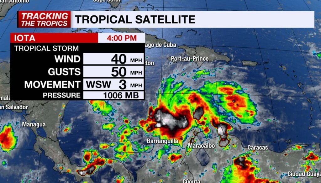
Little over a week after taking the brunt of Hurricane Eta, Central America has been advised to again brace for more devastation, as Tropical Storm Iota formed hours ahead of schedule on Friday (November 13).
Iota, now the 30th named storm in the record-breaking 2020 North Atlantic hurricane season, is projected to make a closely similar impact model as it continues to gather steam in the central Caribbean Sea.
Meteorologists at the US-based National Hurricane Center (NHC) anticipate Iota will be the fifth major cyclone of the season, with a minimum intensity of category three.
“Steady to rapid strengthening is likely over the weekend, and the system is forecast to be a major hurricane when it approaches Central America,” the NHC warned.
According to a 4:00 pm EST advisory, Tropical Storm Iota was located near latitude 13.8 North, longitude 74.3 West—or roughly 540 kilometres south-southeast of Kingston, Jamaica.

The system continues its west-southwest trajectory at six kilometres/hour, packing maximum sustained winds near 65 kilometres/hour, with higher gusts.
In its forecast, the NHC said it heavy rains and dangerous surf conditions pose the greatest threat from TS Iota, with sections of northern Colombia, Panama and Costa Rica receiving up to 12 inches through Wednesday.
Jamaica and Hispaniola could see anywhere between two and six inches of rain as well as vicious swells along the southern coasts of both islands and Colombia as early as Saturday.
“Across remaining sections of Central America, the system has the potential to produce 20 to 30 inches of rain with a focus across northern Nicaragua and Honduras. This rainfall would lead to significant, life-threatening flash flooding and river flooding, along with landslides in areas of higher terrain,” the NHC indicated.

Tropical-storm-force winds extend outward to about 164 kilometres from Iota’s centre, the hurricane watchdog added.
Iota is expected to move across the central Caribbean Sea on a calamitous approach to the coasts of Nicaragua and northeastern Honduras late Sunday or Monday.
See related story below:


Comments