
Hurricane Larry continues to strengthen, poses no direct threat to wider Caribbean

Gavin Riley / Our Today
administratorThree other systems—one in the Caribbean Sea—also being monitored

Hurricane Larry has swelled in size and continues to gather steam in the tropical Atlantic on Thursday (September 2), however, the system is not projected to directly threaten countries in the Caribbean.
According to an 11:00 am Atlantic Daylight Time (ADT) advisory by the US-based National Hurricane Center (NHC), Larry seems poised to enter the rapid intensification phase of its development.
Larry, the 11th named storm of the 2021 North Atlantic Hurricane season, is expected to roar into major hurricane strength tomorrow, the NHC added.
As at 11:00 AST, the centre of Hurricane Larry was located near latitude 13.5 North, longitude 34.2 West. The storm is moving west at a brisk 28 kilometres/hour pace, however, a decrease in its forward speed, as well as a west-northwesterly trajectory, is anticipated over the next few days.
Hurricane Larry is currently packing maximum sustained winds of 130 kilometres/hour, with higher gusts. This places the season’s third hurricane at category one strength.

“Steady to rapid strengthening is forecast during the next couple of days, and Larry is expected to become a major hurricane by Friday night,” the NHC advised.
Hurricane-force winds extend outward up to 30 kilometres from Larry’s centre, while recent satellite wind data indicate that the tropical-storm-force wind radii have expanded and now extend outward up to 260 kilometres.
Sleuths at the NHC are also monitoring three weather disturbances in the meantime.
The first, a small, low-pressure system over northeastern Nicaragua, continues to disorganised shower and thunderstorm activity.
The hurricane watchdog further indicated that a portion of its circulation could hover over the Gulf of Honduras on Friday, sparking the potential for slow, if any strengthening.
“This system could then move over the southwestern Gulf of Mexico during the weekend and early next week, but by then strong upper-level winds would likely limit significant development,” the agency advised, adding formation chances are “low” at 10 and 20 per cent over the next two to five days respectively.
Regardless, the NHC warned heavy rains are possible across portions of Central America and the Yucatán Peninsula through the weekend.

The second, remnants of Tropical Depression Ida, renews its onslaught of heavy rains and gusty winds in the US’ northeastern states.
As at 5:00 am EDT, post-tropical cyclone Ida was located near latitude 41.4 North, longitude 71.6 West—40 kilometres northeast of Montauk Point, New York.
The system, heading towards Cape Cod in southeast Massachusetts, is barrelling northeast at 44 kilometres/hour and packs maximum sustained winds near 65 kilometres/hour, with higher gusts.
Little change in strength is expected.
The third system is a low-pressure system that has just emerged off Africa’s western coast, satellite imagery and recent wind data indicate.
Located 300 miles east-southeast of the southernmost Cabo Verde Islands, the associated showers and thunderstorms already show signs of organisation, according to the NHC.
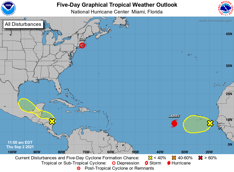
“Some additional development could occur during the next 12-24 hours as the low moves generally westward at about 15 mph. After that time, conditions are expected to become less conducive for development,” the Miami-headquartered agency noted.
Formation chances for the new system are “low”, at 30 per cent over the next two to five days.


Comments