Several communities in West Trinidad inflicted by tornado

Toriann Ellis / Our Today
author
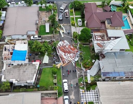
Waterspouts and weak tornado on Tuesday, October 7 damaged and blew off roofs of several houses in north western Trinidad, but there were no immediate reports of injuries or deaths.
Few expected it, but yesterday’s burst of moisture in the forecast turned into something far more dramatic—a tornado.
Based on a combination of eyewitness accounts, social media videos, satellite and radar images, the phenomenon would have begun as a waterspout in the Gulf of Paria near the West Shore Medical Private Hospital, Cocorite. It then moved northwestward in a weakened state, regaining strength over North Westmoorings.
Most of the wind damage was observed in this community, as the Rural Development and Local Government Ministry reported 12 damaged roofs, some of which were completely ripped from the structures below.
This rare weather phenomenon, by local standards, was triggered by an intense thunderstorm over the area. Waterspouts are a relatively common occurrence over the Gulf of Paria, especially when there are hot conditions over land, which was the case over western Trinidad yesterday. Once the sea breeze converges with the prevailing winds along the west coast, winds can begin to rotate. The associated thunderstorm may have provided lift to form a rotating column of air (vortex).
Tornado intensity is measured using the Enhanced Fujita (EF) scale, developed by a Japanese/American meteorologist. The rating estimates wind speeds and associated damage at different levels. Based on the damage in North Westmoorings, the tornado was likely an EF-0 or EF-1.
In the absence of reliable wind data, tornadoes are usually classified by the damage they cause.
However, the scale is mainly used in the United States of America, where building codes differ, making assessments highly subjective. Outside the US, construction quality is also a key factor, and local authorities would need to carry out further evaluation.


Comments